


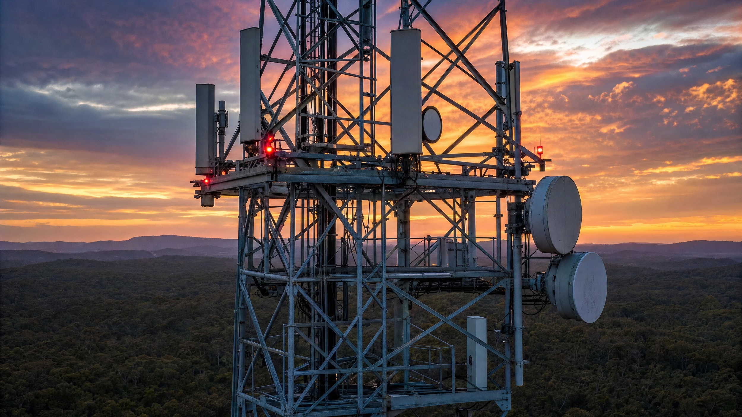
Telecommunications Infrastructure Intelligence
Structural, thermal, and spatial data for tower portfolios at scale. 5-15+ sites per day. Zero climbing. AS 3995 aligned.
60,000+ towers nationally. 5-year structural inspection cycles are mandated. Is your backlog growing?

The Scale of the Challenge
5 years
Mandated structural inspection cycle (AS/NZS 1170, AS 3995).60,000+
Towers and rooftop sites across Australia require periodic inspection. years 25%
Network outages on fibre routes caused by vegetation encroachment.2-4
Maximum sites per day with traditional climbing crews.
Why Climbing Cannot Scale
Crew Scarcity
Qualified tower climbers are limited nationally. Demand exceeds supply. Backlogs grow.Cost per Site
$2,000-$5,000 per climbing inspection. At portfolio scale (5,000+ sites), this is $10M-$25M per cycle.Safety Risk
Tower climbing remains one of the most hazardous occupations. Falls from height + RF radiation exposure.Speed Constraint
2-4 sites/day per crew. A 10,000-site portfolio takes 2,500-5,000 crew-days to complete.Portfolio-Scale Intelligence Without Climbing
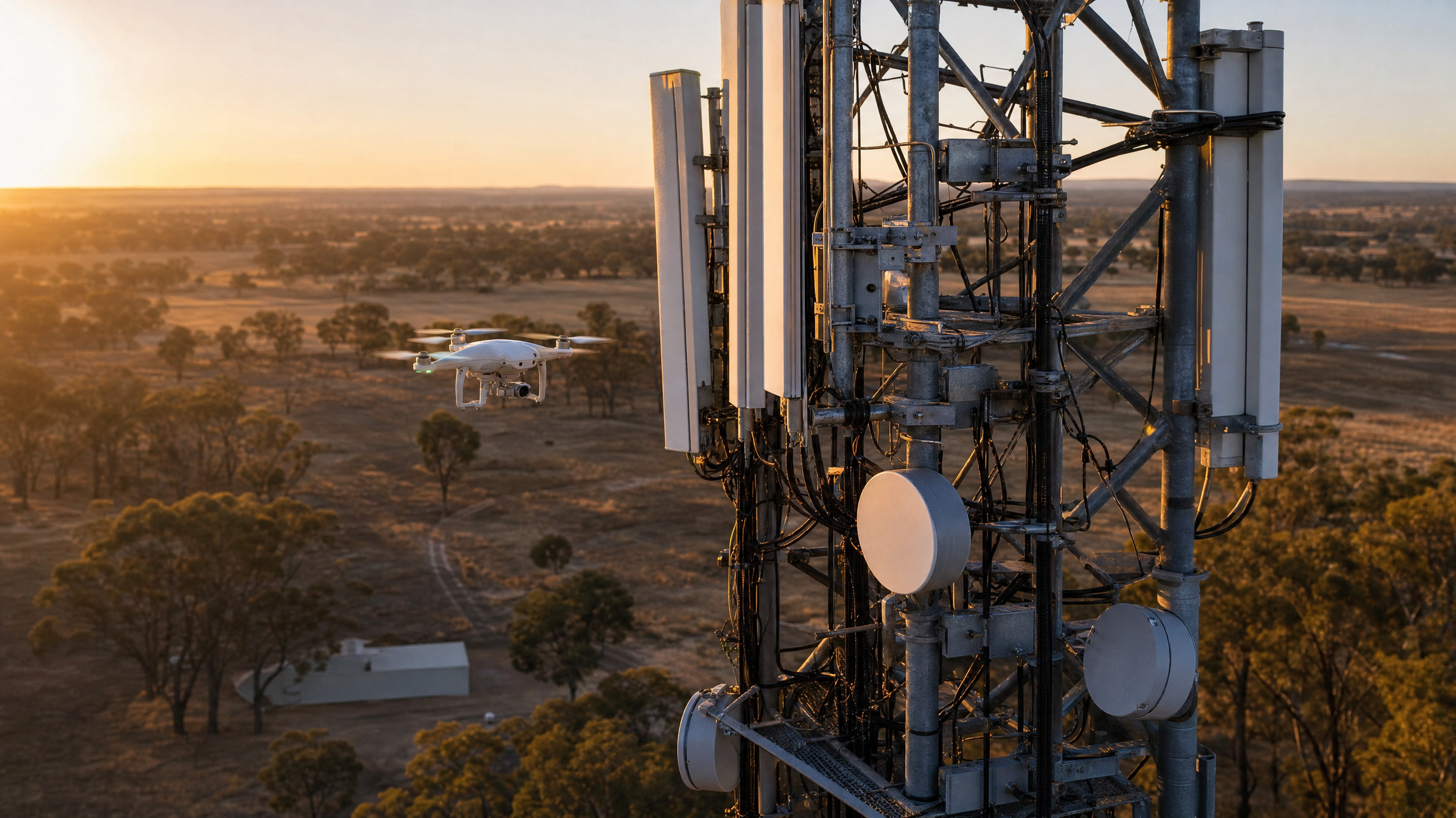
Capture →
Enterprise aerial platform photogammetry +/- LiDAR payload (3cm accuracy, 950m range)Process →
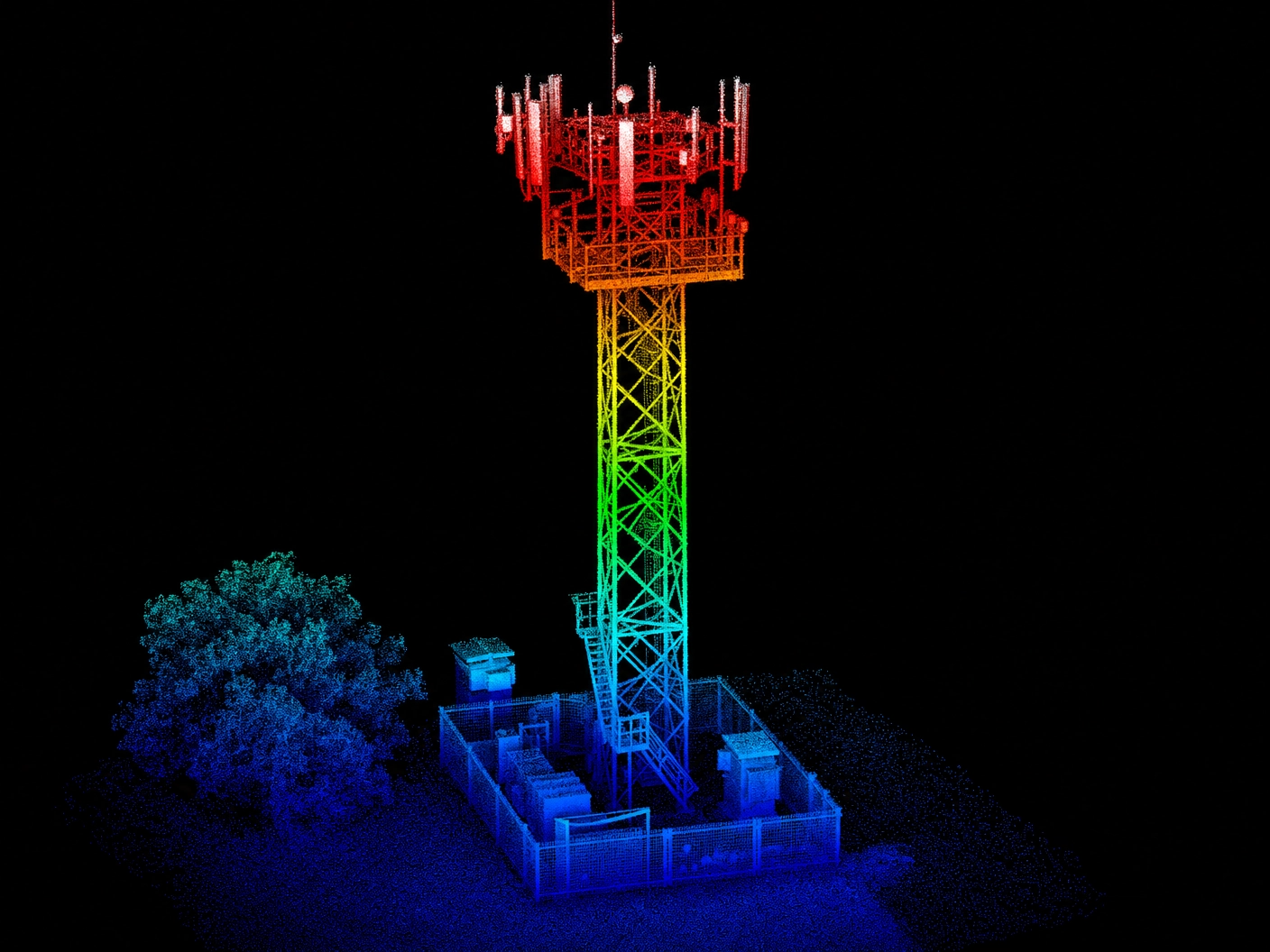
Enterprise reality modelling platformDeepSky IQ delivers independent structural inspection, antenna documentation, and corridor intelligence across your entire telecommunications portfolio at 5-15+ sites per day per crew without climbing, traffic management, or extended site shutdowns. All data is processed through the enterprise reality modelling platform, generating sub-millimetre resolution 3D structural models, corrosion maps, and antenna as-built documentation. Deliverables are accessible via a browser-based 3D viewer; your structural engineers review tower models remotely from any web browser.Analyse →
Corrosion Grading & Defect Detection & TrackingDeliver →
Browser-based 3D viewer Interactive 3D or integratated into your systemInspection & Intelligence Capabilities
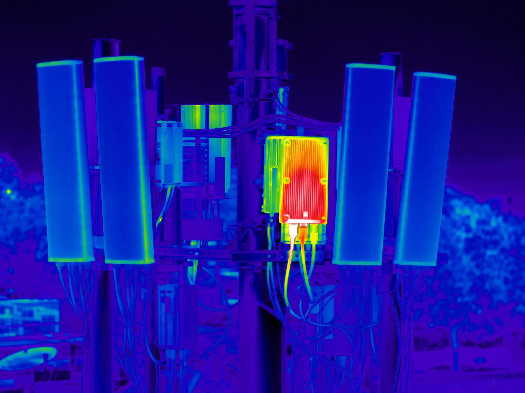
High-resolution visual and thermal inspection of all tower elements. Photogrammetric 3D models enable your engineers to measure deformation, lean and twist without physical access.
- Corrosion mapping referenced to AS/NZS 2312 coating condition standards
- Bolt condition catalogues (every visible bolt captured and graded)
- Weld imagery for integrity review
- Member deformation, lean and twist measurements
- Guy wire condition and tension indicators
- Anchor point documentation
- Foundation condition (visual and thermal)
360-degree documentation of all antenna installations. Digital twin models enable remote engineering review from any browser without RF zone entry.
- Cable run mapping and condition assessment
- Equipment shelter documentation
- Georeferenced imagery for RF planning
- Lease compliance verification
- Co-location assessment and capacity planning
- Thermal hot-spot detection on antenna connections
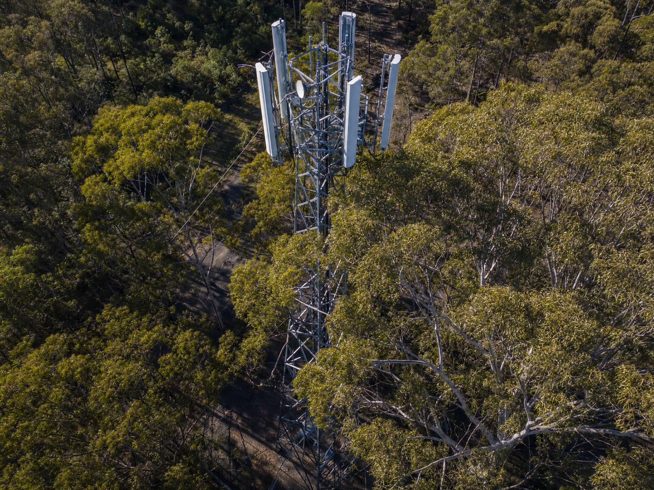
LiDAR vegetation encroachment mapping using vehicle-mounted mobile mapping and VTOL aerial platforms. 500+ km/day capture rate.
- Clearance measurement against standards
- Third-party encroachment detection
- Span measurement and pole condition audits
- Access track condition assessment
- Ground disturbance detection
- Vegetation growth trend tracking between surveys
Low and high-pressure cleaning at heights up to 100m. Extends asset life through regular maintenance without scaffolding, climbing or EWP.
- Tower-mounted equipment cleaning without climbing
- Building facade and rooftop installation cleaning
- Pre-inspection surface cleaning (improves corrosion assessment accuracy)
- Before/after documentation via 3D models
Lattice Towers
Aerial visual + thermal
Condition report, corrosion mapping, bolt/weld assessment, and guy wire tension indicators
Fibre Corridors
Aerial Multispectral, LiDAR + Visual & Vegetation Management Vehicle-mounted mobile mapping system + aerial inspection. Outputs include vegetation clearance, encroachment, and pole audits.Monopoles & Poles
Aerial 360° visual + thermal
Surface condition, base plate corrosion, antenna mounting integrity and climbing peg condition
Exchange Buildings
Aerial thermal + visualRoof condition, HVAC performance, building envelope integrity, security assessment.Rooftop Installations
Aerial visual + thermalAntenna condition, cable management, waterproofing integrity, and structural condition reportingSmall Cells & DAS
Ground 360 Visuals, LiDAR + aerialInstallation condition, mounting integrity, cable management, as-built comparison overlay, and visual documentationGuy Wires & Anchors
Aerial visual, Thermal + LiDAR Wire condition, tension indicators, anchor point corrosion, and ground clearance measurement Tower Surface Cleaning
Aerial & Ground wash platformsPre-inspection cleaning of heavily contaminated structures, equipment washing at height without climbing Measurable Outcomes for Telecommunications
5-15+
Sites inspected per crew per day vs 2-4 sites/day climbing 60-75%
Cost reduction per site vs traditional climbing 500+km
Fibre corridor captured per day (vehicle-mounted and aerial LiDAR)Zero
Climbing required, high risk eliminatedDrone Inspection vs Traditional Climbing
| Asset Type | Traditional Method | Traditional Risk | DeepSky Method | Risk Eliminated | Cost Impact |
|---|---|---|---|---|---|
| Lattice towers (60-100m) | Climber with harness, full ascent | Falls from height | Drone full structural, all faces | Climbing eliminated | 50-70% reduction |
| Monopoles | EWP or climbing pegs | Falls, EWP tip-over | Drone 360° at all heights | Height work eliminated | 40-60% reduction |
| Rooftop installations | Working at building edge, near RF | Falls, RF radiation | Drone from safe standoff | Edge work + RF eliminated | 30-50% reduction |
| Antenna alignment | Climber with tools at height | Falls, RF exposure | Drone photogrammetry, measurement from imagery | Zero human at height | 40-60% reduction |
| Fibre corridors | Ground crews walking route | Vehicle interaction, terrain, wildlife | Aerial + mobile LiDAR | Ground exposure eliminated | 60-80% time reduction |
| Guy wires & anchors | Personnel traversing anchor fields | Trip hazards, remote terrain | Aerial assessment from standoff | Anchor field access eliminated | 50-70% reduction |
| Tower cleaning | Scaffolding or rope access | Falls, chemical exposure | Aerial wash platform (up to 100m) | Climbing eliminated | 40-60% reduction |
Purpose-Built for Telecommunications at Scale
Portfolio Inspection Programs
For tower companies and operators managing 5,000+ sites, we design and deliver structured inspection programs that clear compliance backlogs and establish ongoing condition baselines.
Per-site pricing with volume discounts at 100, 500 and 1,000+ site thresholds. Contact for portfolio-tailored pricing.
Calculate Your Savings

Telecoms Inspection Program Savings Calculator
Estimate the total value of transitioning from traditional to robotic inspection across your network.
Request Your Full Scoping Report
We'll prepare a detailed assessment based on your inputs above, including a tailored inspection program, timeline, and ROI analysis.
Services for Telecommunications
Thermal & Condition Assessment
Corrosion detection, equipment thermal performance, and building envelope“A tower climber can only inspect what they can reach and see from their position. A drone captures every face, every member, every connection in a fraction of the time, without anyone working at height.”
Mobile Corridor Mapping & Intelligence
Multi-sensor vehicle-mounted scanning, including lidar and 360 i8k images for corridor capture on sealed & unsealed roads at speedAsset Inspection & Condition Intelligence
Multi-sensor structural and condition inspectionDigital Twin & 3D to 8D Modelling
Tower and site digital twins for remote engineering review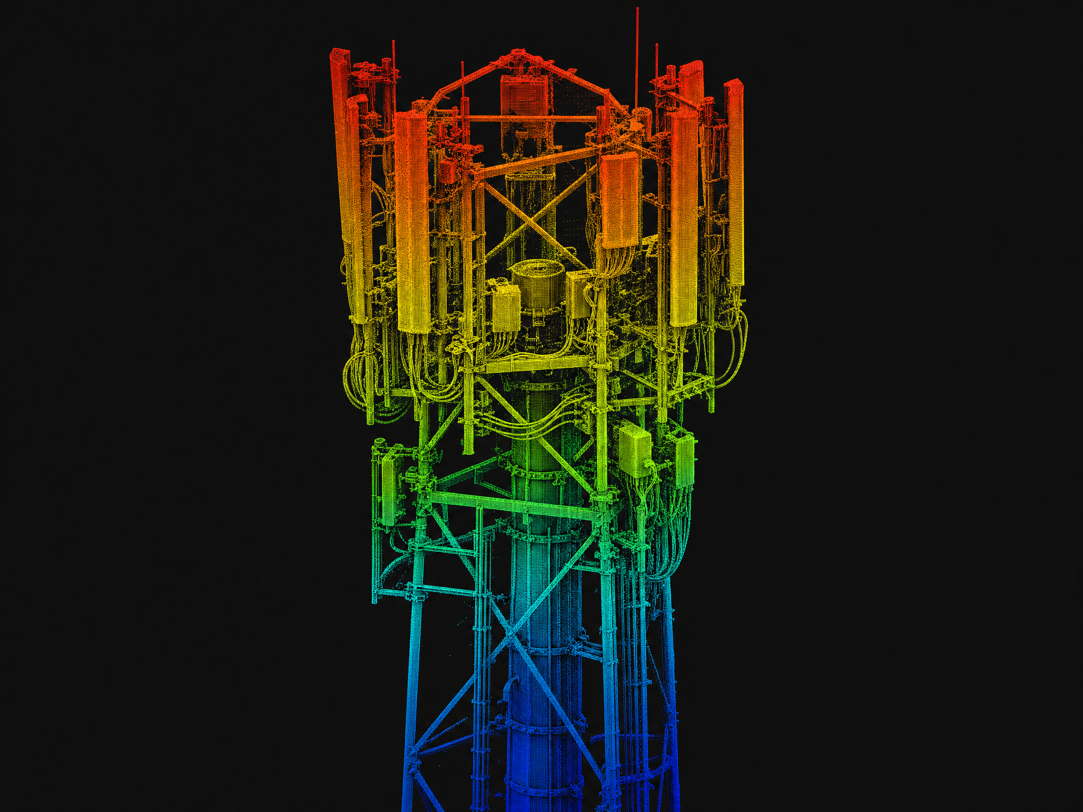
Survey-Grade Spatial & Measurement Intelligence
Corridor mapping, clearance measurement, as-built documentationRecurring Asset Monitoring Programs
Scheduled recurring repeatable inspections with change detection 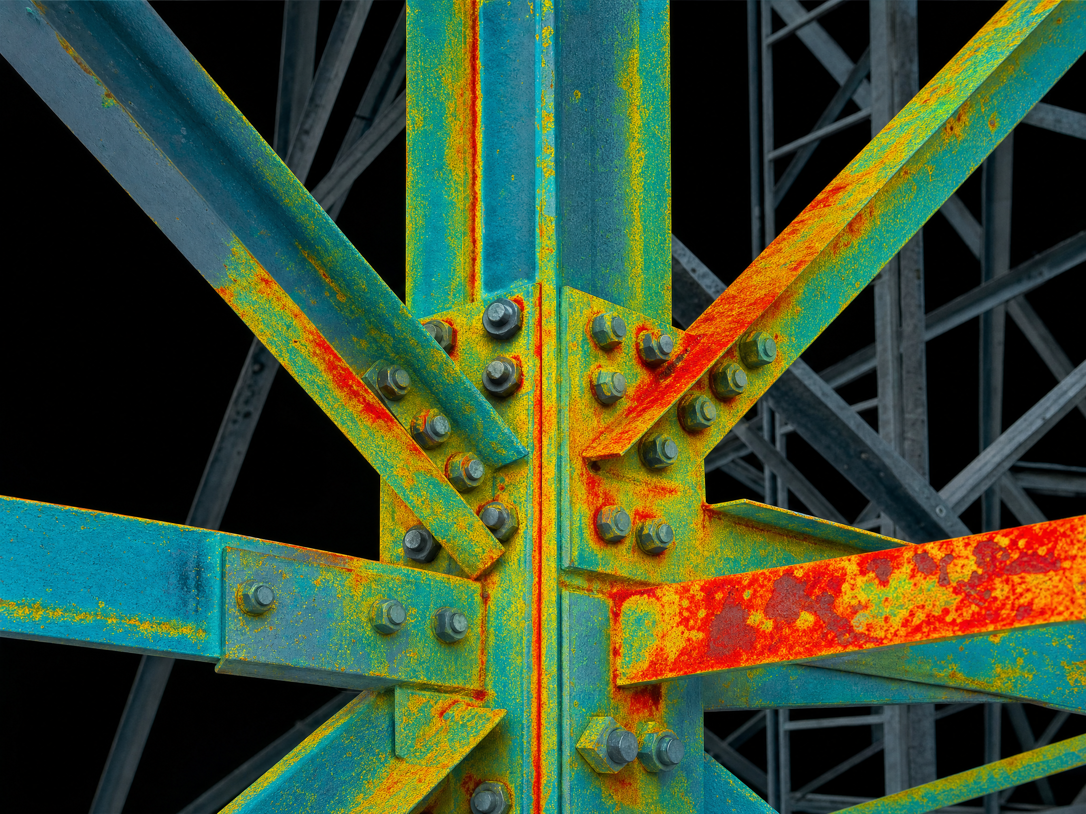

Your Questions, Answered
How much does drone tower inspection cost compared to climbing crews?
Drone inspection typically costs 50-75% less per site than traditional climbing inspection. Climbing crews complete 2-4 sites per day with significant mobilisation, rigging, and safety overhead. Our aerial approach delivers equivalent or superior structural data and completes 5-15+ sites per day. Portfolio programs benefit from step-down pricing at volume, with per-site costs reducing significantly as site count increases.
Can drone inspection replace the structural engineer's assessment?
No, and it should not. We provide the data layer that informs the structural engineer's assessment. Our high-resolution imagery, 3D models, and corrosion maps give engineers more comprehensive information than they receive from a climbing inspection. Engineers review our deliverables remotely via browser-based interactive 3D models, making their assessment faster and more thorough with full 360-degree coverage of every structural member.
How do you handle rooftop installations where building access is restricted?
Our drones inspect from safe standoff without entering the building or working at the roof edge. No building access coordination, working at height permits, or traffic management required. This eliminates the 2-4 week lead time typically needed for rooftop access approvals while delivering superior coverage of all antenna faces, cable runs, and mounting hardware.
What structural standards do your inspection reports align to?
Reports align to AS 3995 (Design of steel lattice towers and masts), AS/NZS 1170 (Structural design actions), and AS/NZS 2312 (Guide to the protection of structural steel against atmospheric corrosion). We work with your structural engineers to ensure deliverables meet their specific assessment requirements and provide the data in formats that integrate with their existing workflows.
Can you survey hundreds of kilometres of fibre corridor in a single campaign?
Yes. Using vehicle-mounted mobile mapping (500+ km/day on sealed and unsealed roads) combined with VTOL aerial platforms for off-road sections, we capture corridor-length vegetation clearance data, pole condition, span measurement, and encroachment detection in a single campaign mobilisation. All data is processed through an enterprise reality modelling platform for automated vegetation analysis and clearance reporting against your defined envelopes.
How many towers can you inspect per day?
5-15+ sites per day per crew, depending on tower type, geographic clustering, and inspection scope. For geographically clustered portfolios (e.g., metro areas), we achieve the upper range. For remote or dispersed sites, 5-8 per day is typical. This compares to 2-4 sites per day with traditional climbing crews, a 3-5x throughput improvement that compresses multi-month programs into weeks.
Do you provide antenna as-built documentation for RF planning?
Yes. We capture 360-degree georeferenced imagery of all antenna installations, cable runs, and equipment. This is processed into digital twin models via enterprise reality modelling platform, providing accurate as-built documentation for RF planning, lease compliance verification, and co-location assessment. Deliverables are accessible via browser-based 3D viewer for remote engineering review at any time.
Can you clean tower structures and equipment at height without climbing?
Yes. Our purpose-built aerial wash platforms deliver low and high-pressure cleaning at working heights up to 100m without climbing, scaffolding, or EWP. This is particularly valuable as a pre-inspection step: cleaning heavily contaminated structures improves the accuracy of subsequent corrosion assessment. Aerial tower washing typically costs 40-65% less than traditional rope-access or EWP methods while eliminating working-at-height safety risks entirely.