
Government and Public Sector
For local, state, and federal agencies responsible for public infrastructure, environmental compliance, conservation, disaster response, recovery and community safety.
"100% network coverage vs 5-10% sample-based "
CASA Certified Commercial Operator
|
ISO 9001
|
ISO 14001
|
ISO 45001
|
$20m Insurance
|
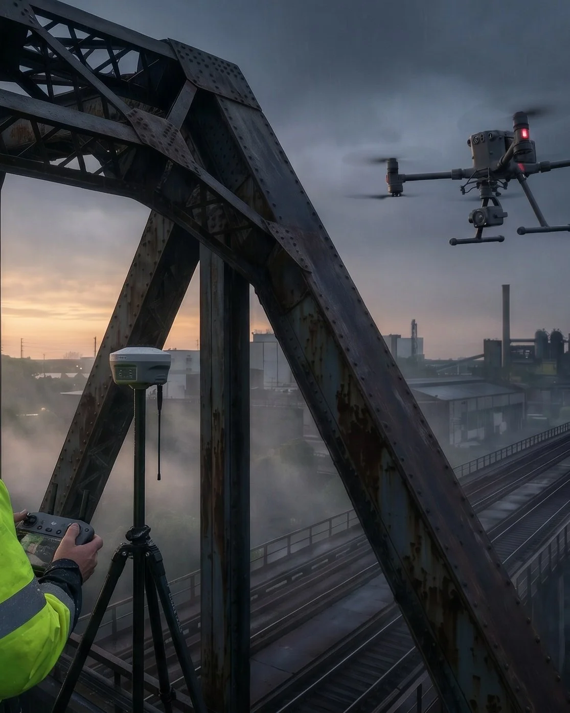
Bridge Level 1
|
CASA Certified Commercial Operator | ISO 9001 | ISO 14001 | ISO 45001 | $20m Insurance | Bridge Level 1 |
The Challenge: Delivering More with Less Under Increasing Scrutiny
Ageing Assets, Constrained Budgets
Agencies must protect assets, boost efficiency, and extend lifespan despite tighter budgets and higher public expectations. Manual inspections create data gaps, raise risks, and drive up costs, hindering effective prioritisation of maintenance and capital works.The Dynamic Environment
Natural disasters demand faster, data-driven preparedness, response, and recovery. Traditional assessment and monitoring are slow, risky, and imprecise, delaying recovery, increasing costs, and undermining resilient planning, leaving communities exposed and resources strained.Community Safety Obligations
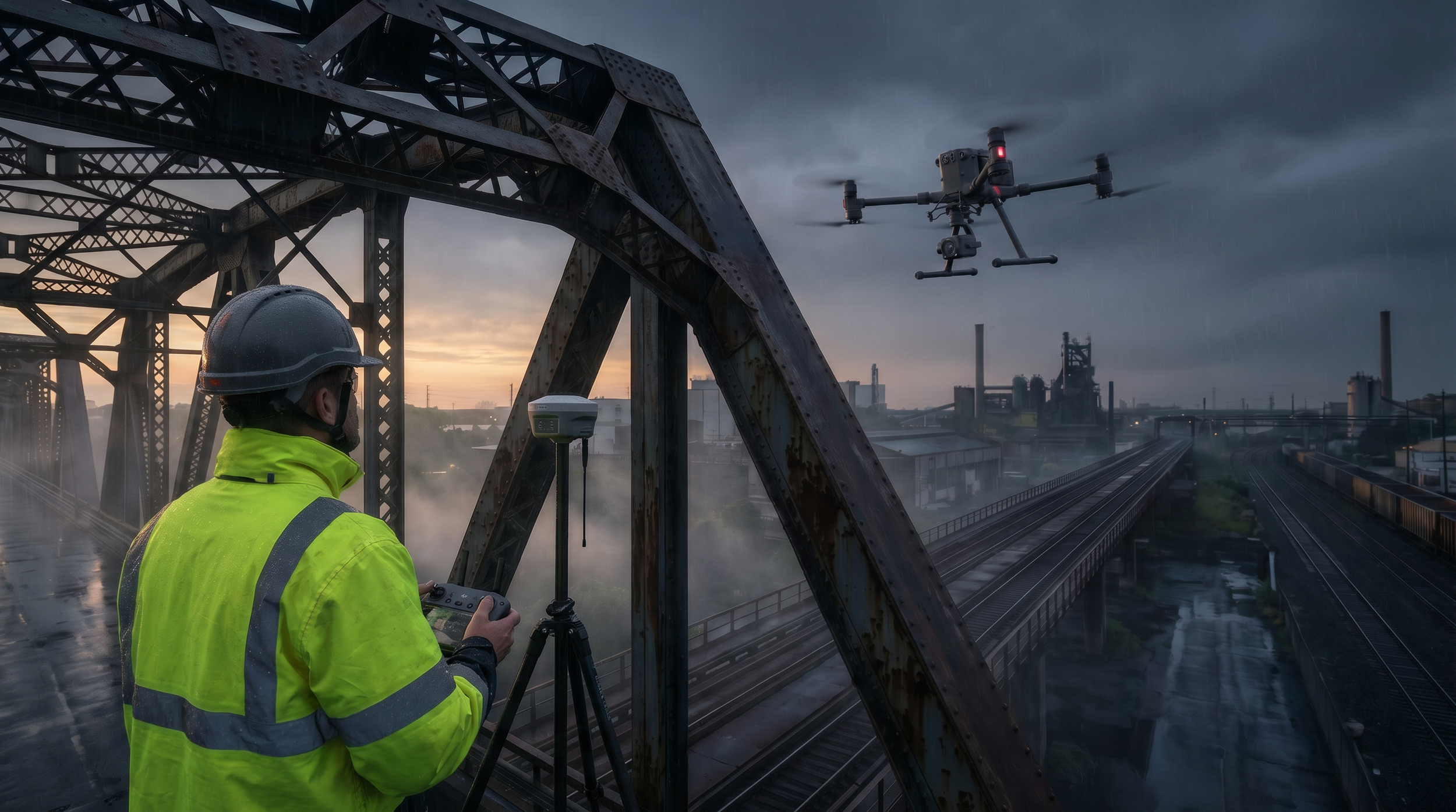
You are responsible for public safety. Managing risks to bridges, roads, and coasts requires precise, actionable data gathered without endangering people. Raw drone and sensor outputs must be converted into auditable, engineering‑grade insight. Without a secure, scalable, compliant system to process, analyse, and visualise data, its value stays locked and Digital Twin and AI adoption stalls.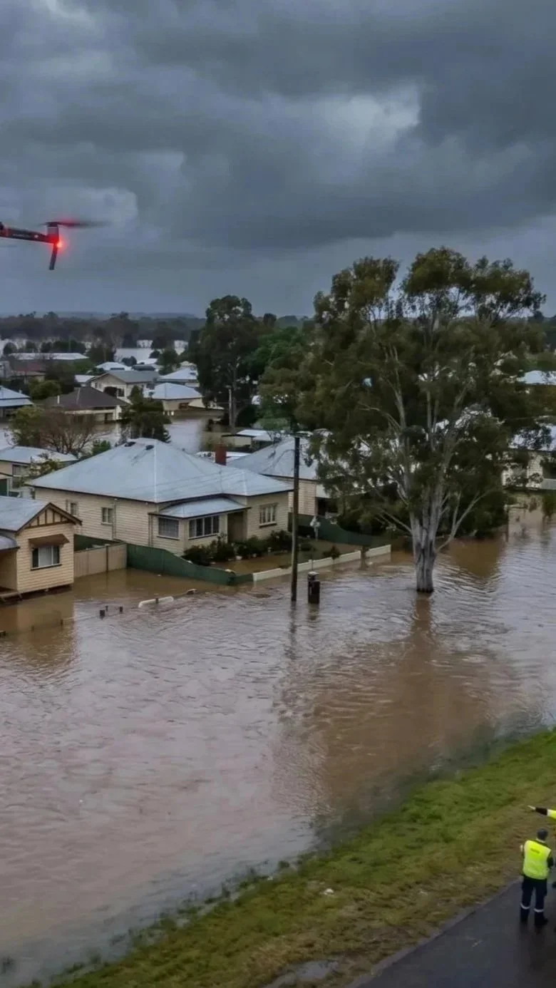
The Solution: A Force Multiplier for Public Services
DeepSky IQ provides an end-to-end asset intelligence solution that acts as a force multiplier for government agencies. We bridge the gap between raw data and actionable intelligence, transforming how assets are managed, monitored, and maintained, giving decision-makers confidence in safety and reliability. By integrating multi-sensor capture technology with advanced analytics, we deliver a unified, audit-ready view of your entire asset portfolio, from critical infrastructure to environmental resources, enabling decisions that improve public safety, optimise budget allocation, and build a more resilient nation.Capabilities:
Comprehensive Infrastructure Audits:
Gain complete condition assessments of bridges, roads, public buildings, and utilities to proactively identify defects and prioritise maintenance.Rapid Disaster Intelligence:
Deploy quickly post-event to capture high-resolution imagery and 3D data of impacted areas, enabling safe, rapid damage assessment and resource allocation.Digital Twin Creation and Management:
Develop and maintain high-fidelity Digital Twins of critical public infrastructure to enhance strategic planning, emergency response simulation, and operational efficiency. Enhanced further with IoT integration for real-time remote monitoring and management for ultimate efficiencyEnvironmental and Regulatory Compliance:
Automate the assessment and monitoring of land conditions, vegetation health, water quality, wildlife and tracking. Monitoring protected ecosystems with verifiable, repeatable data capture for robust compliance reporting.Enhanced Search and Rescue Operations:
Utilise advanced thermal and imaging sensors across aerial and underwater platforms to expand search areas, locate missing persons faster, and increase operational safety. Quantifiable Outcomes for the Public Good
20-30%
65%
“Of the major Australian infrastructure proposals in 2024 was digital engineering including digital twins.”
“Improvement in defensible decisions that improve public safety, optimise budget allocation, and build a more resilient nation.”
$60.7B
“Federal infrastructure budget over 4 years, demanding maximum ROI on every dollar spent.”
Technology for a Smarter State
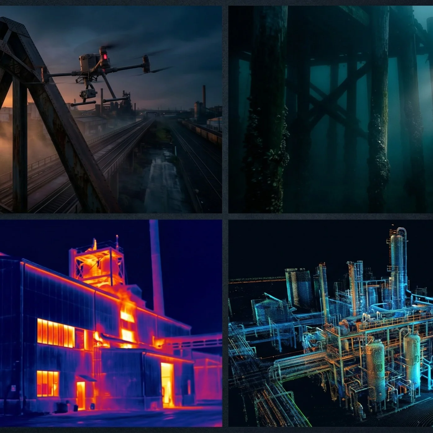
We deploy a suite of best-in-class data capture platforms and sensors to acquire consistent, high-fidelity data across any environment. Our methodology is built on a foundation of: Outcome first. Environment second. Method third. We select the right tool for the job, every time, to deliver data that is not just accurate, but decision-ready.Our fleet includes specialised platforms for small to large-scale surveys, confined space robotics for internal or high-risk inspections and advanced underwater ROVs for inspecting bridge pylons, ports, and reservoirs. By integrating LiDAR, thermal, multispectral, and high-resolution photogrammetry sensors across our platform, we can create datasets that reveal what the human eye cannot see. This multi-sensor approach improves defect detection by 40-60% compared to traditional methods.Our Services
Asset Inspection & Condition Reporting
Infrastructure, assets, bridges, rail, roads, pathways, roofs, facades, facilities, industrial, commercial, recreational and residential for defect detection, tracking, reporting & monitoring.
Confined Space Inspection & Interior Condition Reporting
Infrastructure, assets, pipeline, lift shafts, culverts, silos and tanks for defect and condition tracking, reporting & monitoring.
Reality capture with virtual interactive 3D models of your assets for planning, monitoring and simulation.
Security, Safety, Disaster Response, Search & Rescue
Providing aerial, robotic and underwater inspections, security & remote monitoring for real-time response to support communities, private companies and public safety agencies.
Underwater & Submerged Asset Intelligence
Bridge footings & substructures, water tanks, seabed mapping, pipelines, ports, reservoirs, dams, marinas, cables, hulls, propellers and any other submerged infrastructure.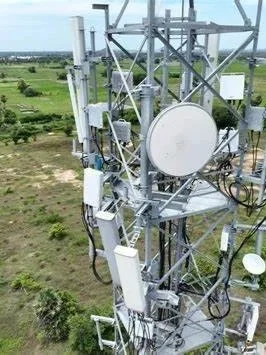
Longer-term trend tracking & data-driven monitoring of asset degradation and environmental changes. Informing decisions to optimise your decisions and save you up to 40% in costs.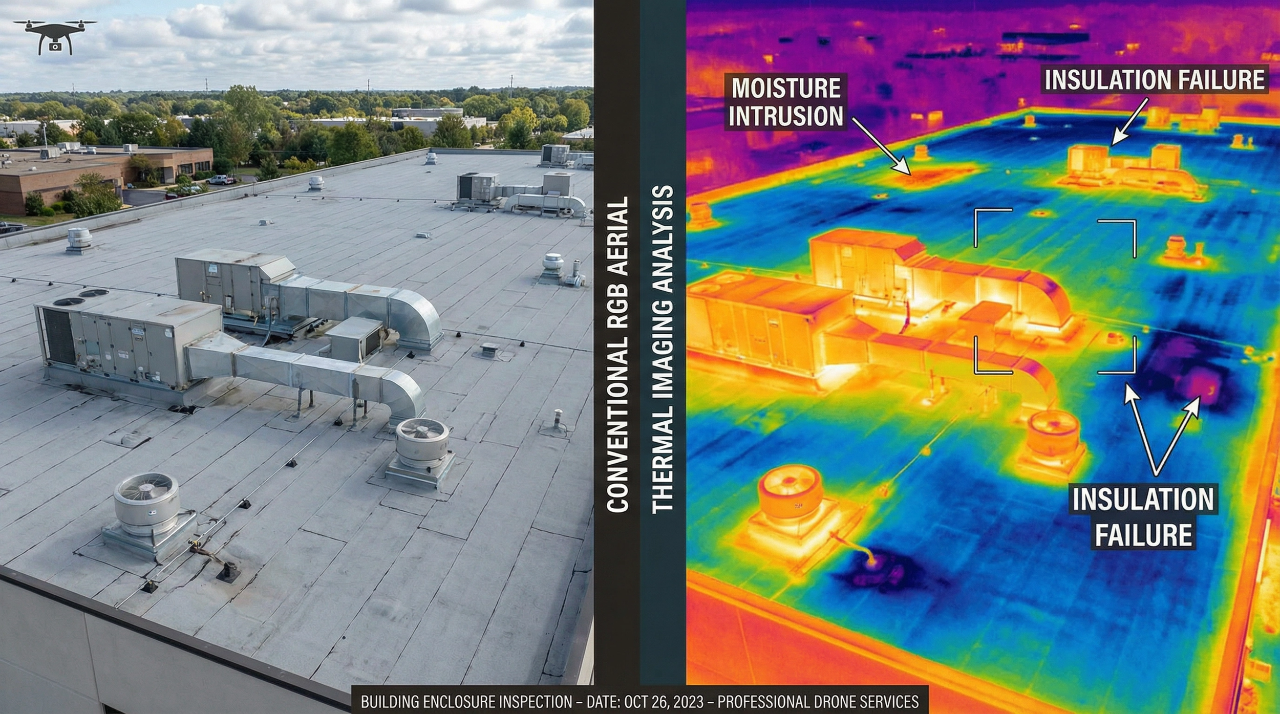
Thermal & Condition Assessment
Identify building envelope failures, leaks, electrical & mechanical faults, moisture intrusion, insulation failures and other non-visible defects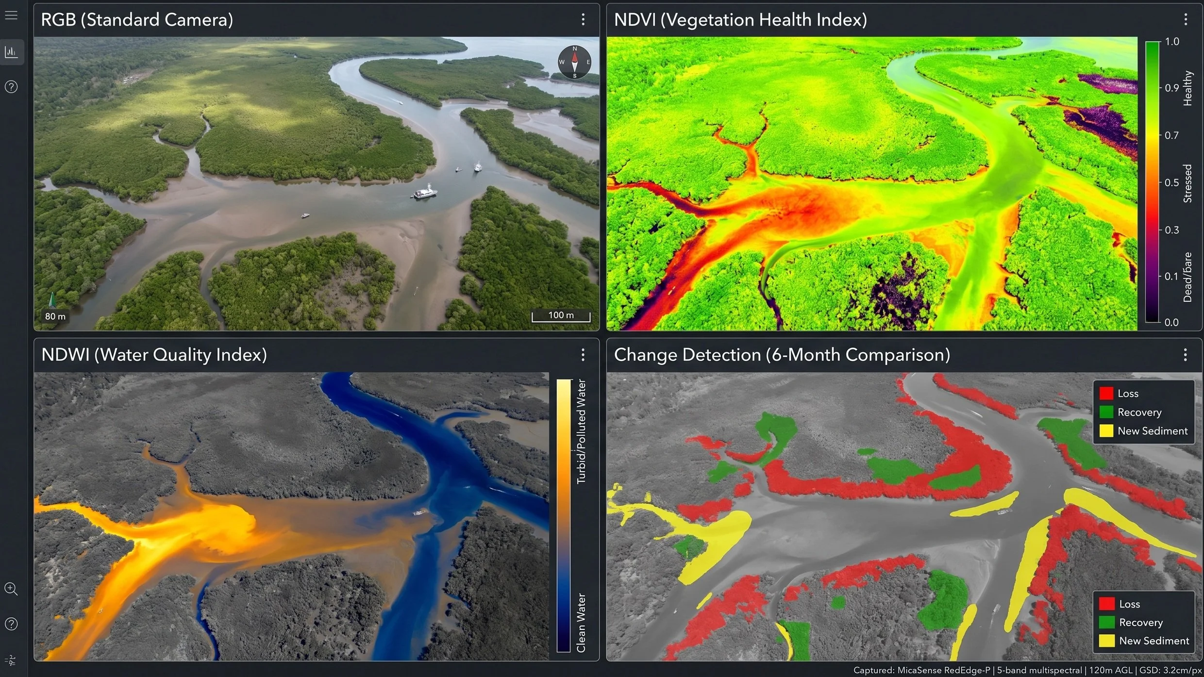
Land, Environment & Conservation
Wildlife surveys, soil, pest, and plant & vegetation health analyses, water quality sampling, precision agriculture, irrigation, terrain mapping, erosion, bathymetric mapping, and environmental compliance. Actionable NDVI, NDRE, GNDVI, OSAVI mappingFrequently Asked Questions
Do you meet government procurement and compliance requirements?
Yes. We operate under ISO 9001 (Quality), ISO 14001 (Environmental), and ISO 45001 (Work Health and Safety) certified management systems. We hold CASA ReOC with advanced endorsements, carry $20M public liability insurance, and maintain documented safety management systems aligned to government contractor requirements. We are experienced in responding to government procurement processes including standing offer arrangements, panels, and direct engagement.
Can you support local government bridge and road inspection programs?
Yes. Local councils managing bridge portfolios of 20-200+ structures often struggle to maintain inspection schedules due to cost and access constraints. Our drone-based methods reduce per-bridge costs by 60-80% compared to traditional UBIUs and rope access, making it feasible to inspect entire portfolios within compliance timeframes. We hold Bridge Inspection Level 1 certification and deliver data satisfying state road authority reporting requirements.
How do you handle data sovereignty and security for government work?
All data is processed and stored on Australian-hosted infrastructure. We operate under documented information security procedures aligned to government requirements. Data handling, retention, and disposal follow your specified protocols. We can work within restricted access frameworks and provide security clearance documentation as required for sensitive government assets and critical infrastructure.
Can you assist with disaster response and emergency management?
Yes. We provide rapid-response aerial, ground, and underwater assessment for post-disaster damage documentation, search and rescue support, and infrastructure condition assessment following floods, storms, bushfires, and landslides. Our advanced CASA approvals (night operations, EVLOS, EBVLOS) enable operations in conditions where standard operators cannot legally fly. Thermal imaging locates individuals in darkness and dense terrain with 98.5% AI-powered detection accuracy.
What public asset types can you inspect?
We inspect all public asset classes: bridges, roads, stormwater infrastructure, buildings, parks and recreation facilities, coastal structures, water and wastewater assets, heritage structures, telecommunications towers, power distribution, and environmental reserves. Our all-environment capability (aerial, ground, confined space, underwater) means a single provider covers your entire asset register regardless of access complexity.
How does this integrate with our existing asset management systems?
We deliver data in industry-standard formats compatible with common government asset management platforms (Assetic, Confirm, TechnologyOne, ESRI). Deliverables include GIS-ready datasets, condition ratings aligned to your existing frameworks, and structured reports that feed directly into your capital works planning and long-term financial plans. Browser-based 3D models provide visual context accessible to all stakeholders without software installation.
Can you support environmental monitoring and compliance for public land?
Yes. We are a Registered Suitable Operator with the Queensland Department of the Environment, Tourism, Science and Innovation. Our multispectral, thermal, and LiDAR capabilities support vegetation monitoring, weed mapping, erosion tracking, waterway health assessment, and wildlife surveys across public land. All data is processed into environmental digital twins for time-series compliance reporting and evidence-based land management decisions.