

Infrastructure and Transport Asset Intelligence
Your Entire Network in Measurable High Definition
One partner for your air, ground, and submerged asset intelligence.
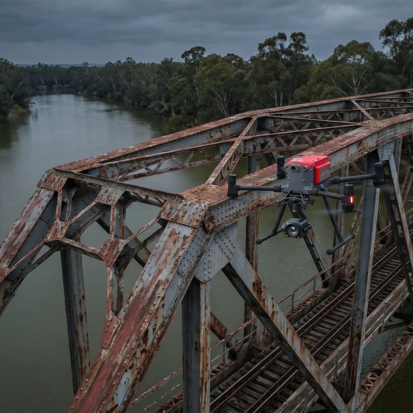
Engineering-grade condition data for bridges, tunnels, rail, roads, and dams. No road closures. No scaffolding. No confined space entry.Bridge inspection 60-80% less than traditional methods.
ISO 9001
-
ISO 14001
-
ISO 45001
-
CASA Certified ReOC
-
$20m Insurance
-
Bridge Inspection Level 1
-
ISO 9001 - ISO 14001 - ISO 45001 - CASA Certified ReOC - $20m Insurance - Bridge Inspection Level 1 -
The Infrastructure Maintenance Challenge
Ageing Networks, Growing Backlogs
Australia's infrastructure maintenance backlog runs into billions. Traditional inspection methods are too slow and expensive to clear the backlog before critical defects become failures. Fragmented Data, Reactive Decisions
Multiple contractors deliver incompatible data formats. No longitudinal comparison. No trend detection. Maintenance decisions remain reactive rather than predictive.Access Costs Exceed Inspection Value
Scaffolding, UBIUs, rope access, and traffic management often cost more than the inspection itself. The Cost of Traditional Infrastructure Inspection
$20k - $80k+
Traditional bridge inspection cost per structure$2k - $5k/day
Traffic management costs for road closuresVs Our Benefit
60 - 80%
Cost reduction vs UBIUs for Level 1 assessments40-60%
More defects detected vs ground-based visual alone40%
Average cost reduction with drone bridge inspectionOne Platform. Every Environment. Total Network Visibility
Tunnels & Culverts
Internal condition assessment without human entry. Spalling, cracking, delamination, water ingress, and structural deformation mapped in 3D. Method: Confined Space specialised drone (caged with SLAM, 4K visual, thermal) + tethered (unlimited flight time for large structures) Minimum opening: 50x50cm Output: Internal 3D reality mesh with mm detailed defect register. Wall condition mapped and classified. Compared against previous inspections for change detections, with optional UTM. Rail Corridors
Track geometry, ballast condition, vegetation encroachment monitoring and management, signal infrastructure, and overhead wiring inspection without track possession.

Method: Enterprise aerial platform + LiDAR payload (corridor mapping at 950m range) + VTOL fixed-wing drone (200km+ corridor surveys), with specialised agricultural drone for vegetation management

Coverage: Up to 200km+ per day

Output: Corridor-wide point cloud with vegetation clearance measurements, asset register, and encroachment alerts. Delivered as GIS-ready dataset.
Find every defect.
Our multi-sensor approach detects delamination, corrosion, and structural defects invisible to the naked eye.Automated defect recognition.
AI-powered analysis automatically identifies, classifies, and tracks defects, providing objective data for maintenance decisions.Predict the future.
Our longitudinal monitoring programs establish data-driven benchmarks to monitor asset degradation and predict future maintenance needs.Enterprise Processing. Advanced Analytics. Complete Asset Visibility.
The same platform is used by state road authorities and major infrastructure owners for asset digital twins. The same platform is used by the US Department of Defence for geospatial intelligence and for infrastructure visualisation.We are tool-agnostic. We select the optimal combination of robotics and sensors to meet your specific engineering requirements and deliver decision-ready intelligence.Aerial Platforms: For bridges, rail corridors, and dam walls.Confined Space Drones & Robotics: Utilising collision-tolerant drones for culverts, tunnels, pipelines, lift shafts and high-risk internal structures.Underwater ROVs: for bridge pylons and dam walls. port infrastructure, marinas, ship hulls and submerged pipelines.Terrestrial Robotics, AR & 360 Camera: For ground-level capture, high-resolution imagery, high-risk spaces, gas detection, AR walk-throughs, and interior mapping.One procurement, four environments.
Stop managing four contractors. We cover air, ground, confined space, and underwater in a single program.Bridges & Overpasses
Soffit, abutment, bearing, expansion joint, and deck condition assessment. Crack detection to 0.1mm resolution. Level 1 certified inspection data. Method: Enterprise aerial platform (48MP+ imagery, thermal, LiDAR) + Flyability Elios 3 (internal box girders) Coverage: Multi-bridge programs via route-based scheduling Output: Structural condition model with defect classification, severity grading, and measurement. Delivered via Cesium Ion for remote engineering review. Exportable to GIS, EAM, or BIM platforms. Dams & Retaining Walls
Dam wall structural condition, spillway inspection, seepage detection, and submerged infrastructure assessment.Method: Aerial LiDAR + Thermal (seepage mapping) + ROV (submerged face, outlets, valves)Coverage: Above and below the waterline in a single engagementOutput: Complete dam digital twin combining aerial, thermal, and underwater data in one unified model. Change detection overlays for quarterly monitoring.Road Networks & Pavements
Full network condition capture at traffic speed. Pavement distress, signage, drainage, kerbing, and cross-section profiles.

Method: Vehcile mounted LiDAR mobile mapping platform + 360 cameras (40km/h, 2cm accuracy out to 100m)

Coverage: 50-100km per day, no road closures

Output: Network-wide condition heatmap with automated defect classification. Cross-section profiles, drainage analysis, and maintenance prioritisation delivered via interactive web viewer.
Our Technology:
The Right Tool for Every Environment
The Value
20-40%
Cost Reduction
Eliminate expensive scaffolding, rope access, lift higher, traffic closures & safety staff. Our remote capture platforms directly impact your operational budget 90%
Risk Mitigation
Remove humans from hazardous environments. Our robotic solutions for confined space, working at height and underwater inspections represent a monumental step forward in WHS65%
Digital Engineering Adoption
Meet modern standards for funding and approval. With 65% of major infrastructure proposals now including digital engineering, our data-first approach is the new expectationInfrastructure Inspection Program Savings Calculator
Estimate the total value of transitioning from traditional to robotic inspection across your infrastructure assets.
Request Your Full Scoping Report
We'll prepare a detailed assessment based on your inputs above, including a tailored inspection program, timeline, and ROI analysis.
Services
Deploy advanced infrastructure inspection drones to capture high-resolution visual and thermal images of bridges and road assets without scaffolding. 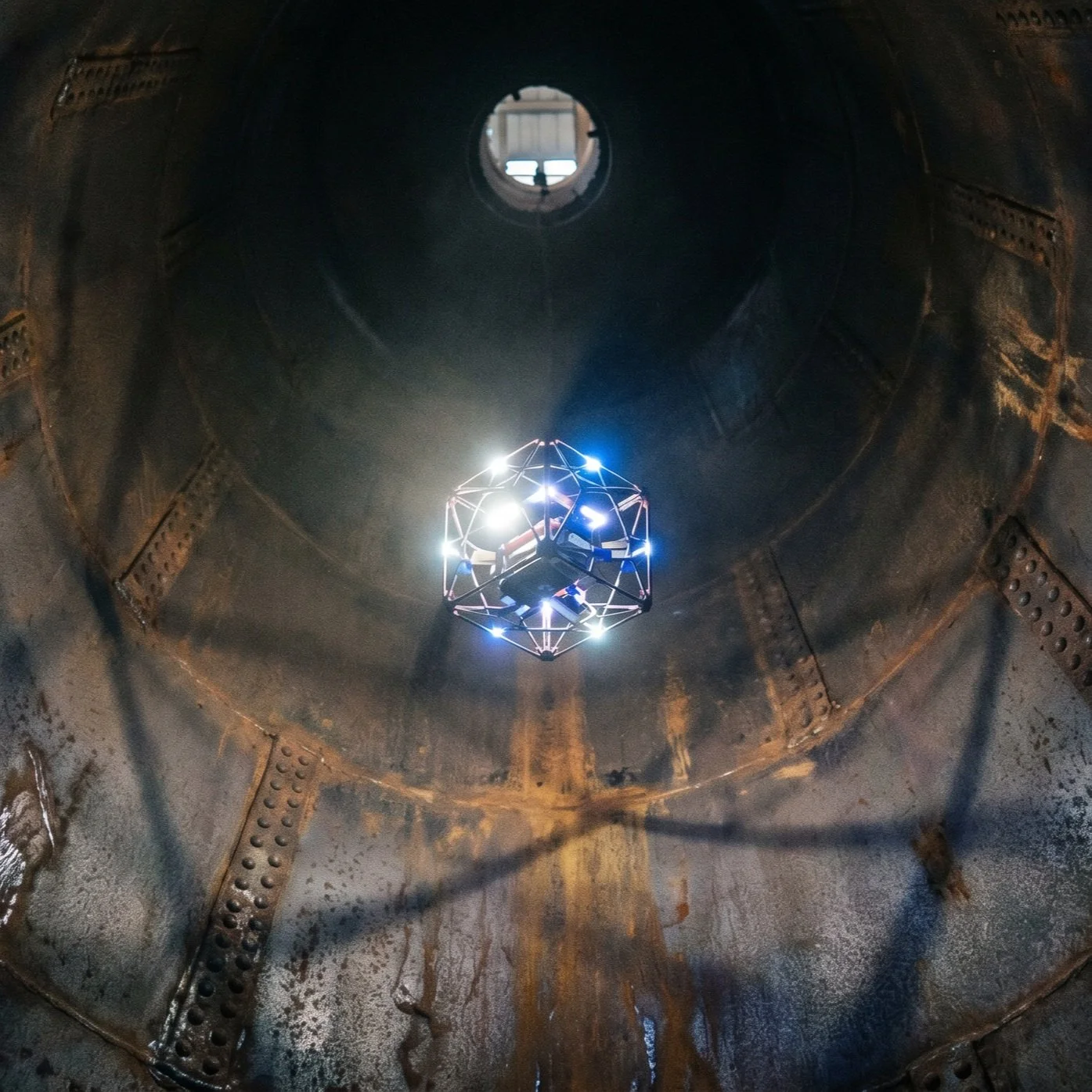
Utilise specialised confined space, lidar, ultrasound NDT-capable & collision-tolerant drones for tunnels, pipelines inspection and culvert assessments, eliminating human entry into hazardous environments.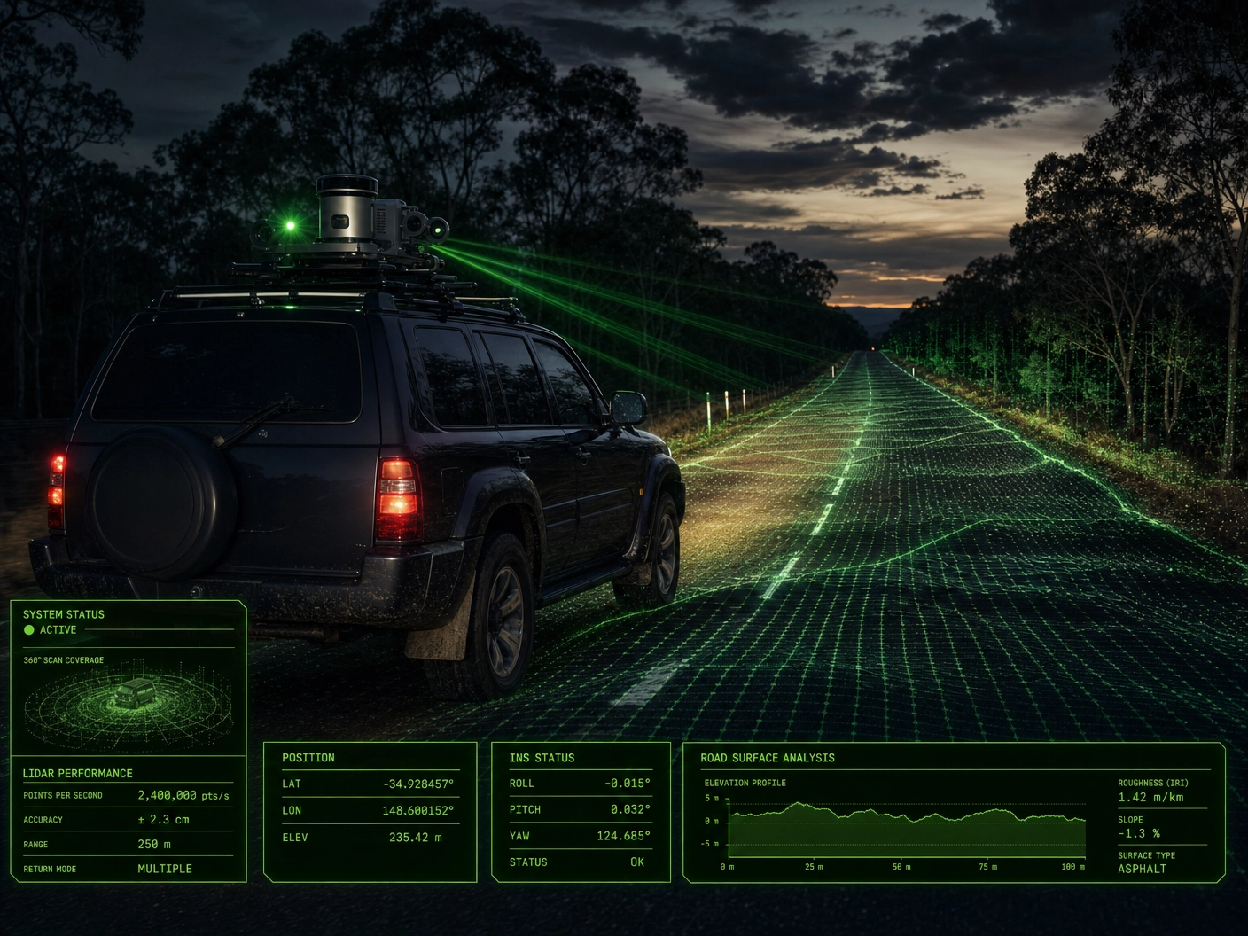
Road Intelligence & Mobile LiDAR Network Capture
Capture your entire road network at 40km/h. No closures. 2cm accuracy. 360-degree measurable digital twins for councils and asset managers, don't just capture it, measure it.Our enterprise-grade data capture programs and condition reporting support the maintenance of bridges, tunnels, rail corridors, road assets, dams, retaining walls, and culverts.
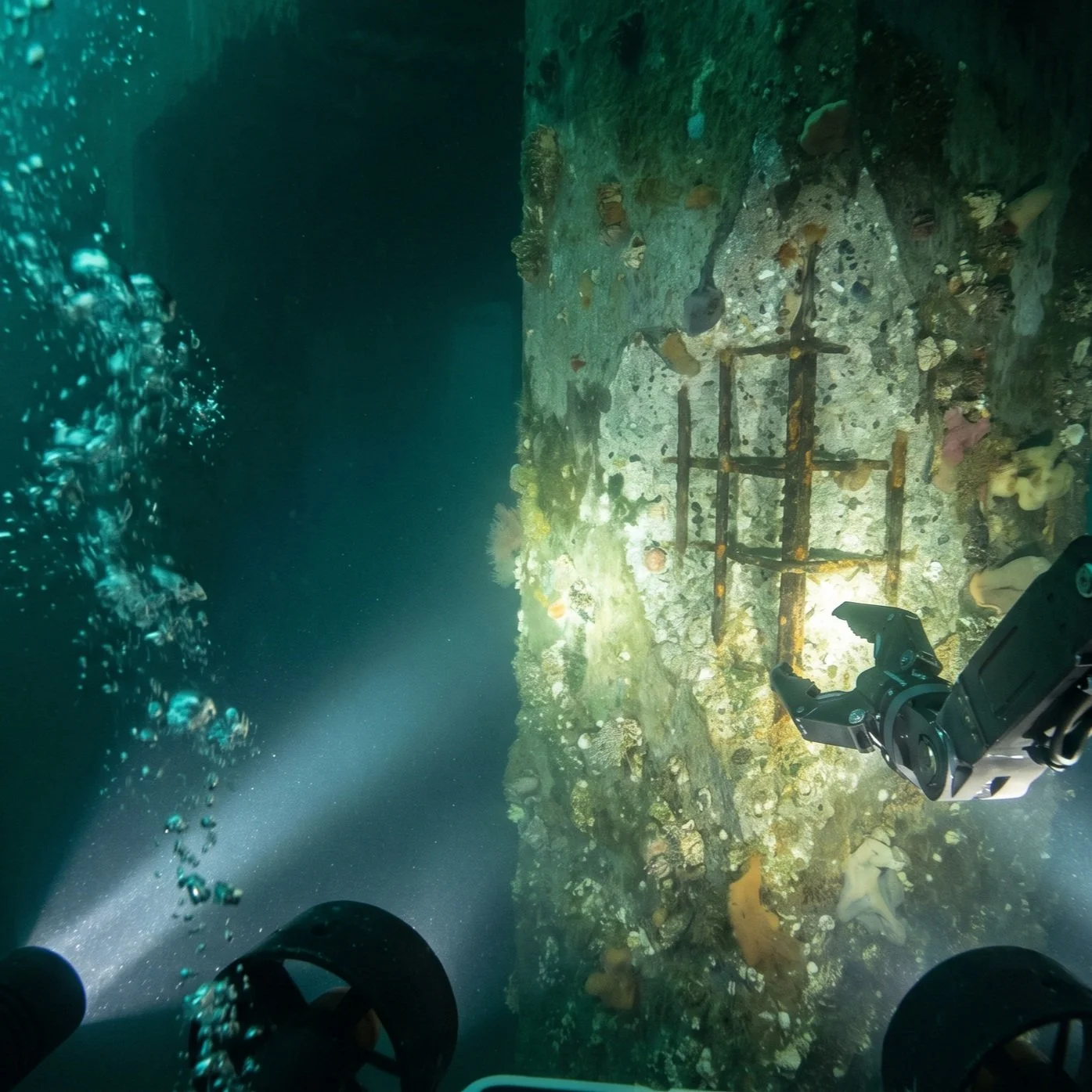
Inspect bridge pylons, dam walls, culverts, underwater ecosystems and submerged infrastructure using enterprise-grade ROVs and integrated digital twins.
Digital Twin & 3D Asset Monitoring
Convert drone data into precise 3D models, enabling remote condition monitoring, time comparison monitoring, and capturing precise defect measurements.20-40% reduction in inspection costs
40-60% improvement in defect detection
Up to 90% risk reduction
20-40% reduction in inspection costs 40-60% improvement in defect detection Up to 90% risk reduction
Frequently Asked Questions
Can you inspect infrastructure and traffic corridors without closing them to traffic?
In most cases, yes. Our remote methods significantly reduce or eliminate the need for traffic management and asset closures, minimising public disruption. We utilise advanced zoom payloads, spotlights, and operate under CASA approvals that often allow inspections without full road closures or rail track possessions.
What level of detail and accuracy can your inspection drones capture?
We capture 4K or 8K video and high-resolution 48MP+ imagery. We use powerful onboard lighting to identify and track micro-cracking, spalling, and corrosion in tunnels and culverts. Using RTK/PPK and GCPs enables detailed defect analysis and reliable change detection comparisons. Our methods are 40-60% more effective than ground-based visual assessment alone. We also use LiDAR to achieve millimetre-level detail, photogrammetry, and thermal radiometric data as your deliverables demand.
How does this integrate with our existing systems?
Our data is provided in industry-standard formats (LAS, OBJ, CSV, GeoJSON) for easy import into your existing GIS, EAM, or standard digital engineering platforms. We also provide secure, cloud-based access to 3D models, orthomosaics, and annotated defect reports via browser-based viewer accessible from any device without software installation.
How much does drone bridge inspection cost in Australia?
Drone bridge inspection typically costs 60-80% less than traditional methods using under-bridge inspection units (UBIUs), rope access, or scaffolding, which also require traffic management plans. The cost reduction comes from eliminating heavy access equipment, lane closures, and the 3-5 day mobilisation windows that traditional bridge inspection demands. Multi-bridge programs achieve further savings through route-based scheduling.
What Australian standards apply to bridge inspection?
Bridge inspection in Australia is governed by AS 5100 (Bridge Design), the RMS Bridge Inspection Procedure Manual, and state-specific guidelines including TMR (QLD), VicRoads (VIC), and DPTI (SA) standards. Level 1 inspections require visual condition assessment of all accessible components. Level 2 inspections require detailed measurement and testing. DeepSky IQ holds Bridge Inspection Level 1 certification and delivers data that satisfies Level 1 reporting requirements, with resolution and accuracy sufficient to inform Level 2 scoping decisions.
Can drones replace under-bridge inspection units (UBIUs)?
For Level 1 condition assessments, drones can replace UBIUs in the majority of cases, delivering equivalent or superior imagery at 60-80% lower cost with zero traffic disruption. Drones capture high-resolution imagery (48MP+) of bridge soffits, abutments, bearings, and expansion joints from multiple angles, often revealing defects obscured by the fixed viewing positions of UBIUs. For Level 2 inspections requiring physical testing, drones serve as a scoping tool to identify areas requiring hands-on investigation, reducing UBIU deployment time by 50-70%.
Do you need road closures for drone bridge inspection?
In most cases, no. DeepSky IQ operates under advanced CASA approvals including Extended Visual Line of Sight, night operations, and operations near traffic. Our pilots conduct bridge inspections from adjacent land, under the bridge deck, or from positions that do not require lane closures. For bridges over major highways where overflight is unavoidable, we coordinate with traffic authorities to utilise existing low-traffic windows rather than full daytime closures.
How often should bridges be inspected in Australia?
Australian state road authorities generally require Level 1 visual inspections every 2-3 years and Level 2 detailed inspections every 5-6 years for standard bridges. High-risk structures (those with known defects, high traffic volumes, or age over 50 years) may require annual monitoring. Local councils managing bridge portfolios of 20-200+ structures often struggle to maintain these schedules due to cost and access constraints. Drone-based inspection reduces per-bridge costs by 60-80%, making it feasible to inspect entire portfolios within compliance timeframes.
What is the accuracy of drone inspection compared to manual bridge inspection?
Drone-based bridge inspection using high-resolution cameras (48MP+) and LiDAR achieves crack detection down to 0.1mm width at typical inspection distances, compared to 0.3-0.5mm for unaided visual inspection from UBIUs. Studies indicate that drone-based methods detect 40-60% more defects than traditional visual assessment alone, particularly in areas with limited access such as deep soffits, internal box girders, and high abutment faces. The addition of thermal imaging further improves detection of delamination, moisture ingress, and reinforcement corrosion.
What is the typical turnaround time?
This varies with asset scale. A standard bridge inspection typically takes between half a day and 3 days to capture, depending on complexity, and can be virtually available to you the same day, with 5-7 days for full processing and reporting. Multi-bridge portfolio programs are scheduled to maximise route efficiency and minimise mobilisation overhead.